RYA-tips #41 – Electronic charts -Not to be used for navigation-
Zeilen is een combinatie van wetenschap en kunst. En voor wie daar meer over wilt weten schrijft Albert De Nijs, instructeur bij de De Zeezeilers van Marken wekelijks een rubriek met tips&trics van de Royal Yachting Association.

Electronic charts are slowly replacing paper charts on yachts. They are convenient and easier (and cheaper) to carry and update than a stack of paper charts.
Confusingly these (unofficial) charts for leisure vessels are labelled ‘not for navigational use’.
Navionics states: The nautical chart, whether paper or electronic, is not designed and built for instrumental navigation, but for orientating visual navigation.
Let’s look a bit further at some of the reasons behind this chartmaker’s statement.
Leisure charts lack the rigorous checking, validation, update and distribution mechanism of ENC’s as used in commercial shipping. These systems (ECDIS and ENC’s) needs to be fully redundant, with a separate power source.
Leisure charts are updated regularly, but it is unclear what data is used as basis for these charts. ‘Navionics information comes from multiple public and private sources, including government and Hydrographic Office charts, our own survey data, as well as Community sonar logs’ (source: Navionics Customer Support).
On your display system, you can find when you downloaded your chart, but you cannot check when the chart was updated or which source-data was used (maybe even ‘user generated content’). There is no list of included Notice to Mariners.
Another issue is that there is no minimum approved standard for display and function for chartplotters. Colours and chart symbols are not standardised, possibly leading to confusion.
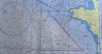
When zooming out to create overview, the chartplotter/chart combination reduces clutter. Critical safety information can just disappear from view. Shoals and small islands should be ‘permanently shown’, but can easily disappear when zooming-out, showing white – ‘safe-water’.
When passage planning it is important to check your route with an up-to-date paper chart or raster chart to identify any discrepancies in an early stage. On vector charts zooming in and out is essential!
Albert de Nijs, Dutch Offshore Sailing Academy