
RYA-tips #25 – Routing software – the search for ‘windows of opportunity’
Zeilen is een combinatie van wetenschap en kunst. En voor wie daar meer over wilt weten schrijft Albert De Nijs, instructeur bij de De Zeezeilers van Marken wekelijks een rubriek met tips&trics van de Royal Yachting Association.
This time we will have a look at weather routing software, and how this tool can help you in finding the optimal departure date/time and route. Recently we discussed weather planning (article #19) and passage planning (article #24) and routing is a logical next step.
For shorter offshore trips (<24 hrs) you can guesstimate where you will be at a certain time and what the wind-vector will be. For longer passages that becomes quite complicated, especially with frontal passages. Routing software helps in organising this information and allows quick analysis of options.
When we look at a trip, we measure the distance, and a conservative passage speed gives some idea of time. To calculate this (a lot) more accurately, we can use the performance diagram of the yacht (polar). This gives boat speed for all wind angles and speeds. These are optimum values, based on displacement, length waterline, sail configuration etc. For your type of sailing you can apply a factor, for example 90% efficiency. It is also possible to indicate at which speed you will switch on the engine to maintain progress.
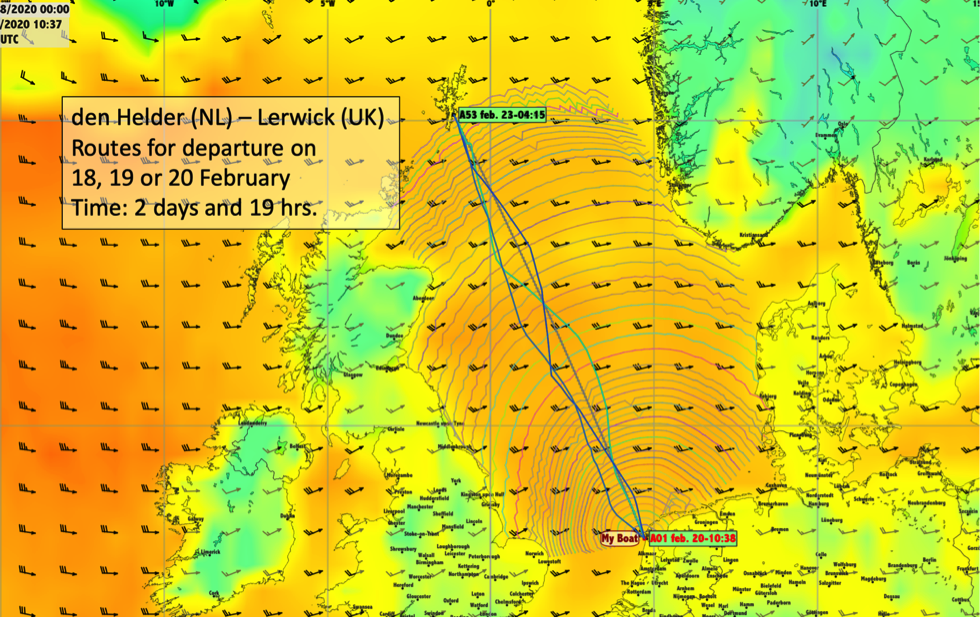
The program needs a starting point and destination, you can simply click on the chart or enter latitude and longitude.
Weather information comes from GRIB files. Select an area covering your passage and a GRIB source with sufficient duration, and download the file. Wind direction and speed, isobars, wave height are just a few of the options available. Normally GFS GRIB’s with 0.5° spacing for 7 days will do nicely.
With the boat’s performance information, the program can calculate where you’ll be at any given moment and use the associated GRIB’s to find the boat speed. Route optimising is typically an easy job for computers. Given a departure date/time, the software can calculate the fastest route, with optimum tacks. It can also compare routes with different departure times, and show you the quickest passage or the best option to avoid beating, prolonged motoring, heavy winds etcetera.
When planning 3 days ahead for a 3-day offshore passage, you are running towards the end of the GRIB’s reliable forecast period. Longer term forecasts are more an indicator of possible developments. It is advisable to (re)run the program with the latest GRIB’s available.
Once onboard, you can feed the actual boat position into the program. If you update the GRIB’s, you can optimise the route again, based on your current position and most recent weather information.
In this article we discussed generic routing software. Many different programs are available, a freeware option is qtVlm (by Meltemus) using GRIB files running on a laptop.
This program focusses on weather routing and doesn’t do navigation routing. It will not avoid wind-farms, shallows or know the correct way to cross TSS’s, it does keep you clear of land though!
Especially for longer passages this software is very helpful in optimising the departure date/time and planning the route and optimum tacks.
Albert de Nijs, Dutch Offshore Sailing Academy